Showing posts with label Eravikulam. Show all posts

Wednesday, September 02, 2015

Thoovanam - A Caressing Drizzle

Some nine years ago, Kurinji or Neelakurinji (Strobilanthes kunthiana) flowers had bloomed in Munnar. Having heard about the beauty of hillsides carpeted with this eccentric plant, that chose to flower only once every twelve years, I had driven off with much enthusiasm. Unfortunately, the best laid plans of men and mice don't always turn out the way it is supposed to. A heavy logjam of traffic at the Eravikulam National Park spoilt the chance of reaching anywhere near the elusive kurinji! After waiting for an hour we realized that we were getting nowhere and rumblings from somewhere near the middle of the anatomy helped make up our minds. A decision was made. We would return for the kurinji, later that season or after twelve years!

It was on that trip I discovered Chinnar, a small wild life sanctuary lying between the Kerala-TN border and Marayoor. Halfway along the ghat road below Marayoor is a wide curve from where I first laid my eyes on Thoovanam falls. Lying below the road and in the middle of a valley, it was in full flow then.

I had made enquiries then, about access to the sanctuary, and found that they offered treks into the forest. I returned a few days later and did two small treks, one to a place with some rock art and another along the river.

It was three years later that I went past Chinnar again, in 2009. Thoovanam was a trickle after a long dry summer.

My desire to trek to the bottom of the valley to feel the 'thoovanam', translatable as a light drizzle or a drizzle carried in the breeze, wasn't fulfilled and the few times I drove along that road, I did not have time for a three hour trek. Finally, I found a weekend and resolved to trek to this waterfall that had been tempting me for so many years.

2nd August, 2015

To access the Thoovanam falls you have to first reach the Alampetty EDC counter on the road to Marayoor. From Palakkad the route goes through Pollachi (45 kms) and Udumalpet (75 kms). At Udumalapet you have to get on the Munnar road. There is a divider all along the Pollachi - Udumalapet road within the town so you have to go to the end of the road, make a U-turn and come back to get on the Munnar road.

Now that the railway overbridge work is complete you don't have to take any confusing deviations inside the town. The Munnar road has a series of check posts starting with the police check post at Amaravathinagar (91 kms). The Tamilnadu forest department (TNFD) check post was immediately next to this but has been shifted further up on the road at the entrance of the Anaimalai Tiger Reserve (formerly Indira Gandhi National Park and WLS). You have to make an entry here and again at another TNFD check post the TN-Kerala border. Immediately after crossing the bridge on Chinnar river, that marks the state boundary, you drive into Kerala through a series of check posts; excise, commercial taxes and the Kerala Forest department's. You have to again enter details at the last check post that marks the start of Chinnar WLS (104 kms). 

The forest department has a rest house and dormitory here if you want to do an overnight trip. The eco-development committee has a small canteen where you can pre-order food if you are staying. The river trek and watch tower trek starts from here. The Alampetty EDC counter (116 kms) is halfway up the road to Marayoor from the Chinnar WLS entry. You can book your trek to the megalithic burial sites (dolmen or muniyaras), Thoovanam and Vasyapara from here. A tribal trekker guide will accompany you from here till you return.

The trek to Thoovanam follows a general downhill course from the EDC counter and the distance is approximately between three and four kilometers, depending on the little short cuts your guide might take you on. In any case it is an easy paced walk even for inexperienced trekkers. With the exception of a couple of slightly steep but short climbs it is overall a trek that can be done without too much of effort.

The shy barking deer
Along the way you will encounter many of the forest's true owners. The gaur and elephant are rarely seen but their presence is well documented on the ground by the dung. Wild boars can also be found blundering around the under bush occasionally.
Fresh steaming dung can be a magnet for some creatures!

Some, like these dung beetles fight over it!

Chinnar is rich in avian life and can occasionally throw up unexpected surprises.
This rufous bellied eagle was a first for me
   
A brown fish owl

If you are able to look above your head and around your feet, you'll see more interesting creatures. Chinnar's two famous residents are the grizzled giant squirrel and the star tortoise. I saw the former during this trek. Very shy and elusive they hide quickly.

Grizzled giant squirrel

They move fast and are difficult to photograph in the dense canopy

Grizzled giant squirrel
The other star of Chinnar, the star tortoise can also be seen frequently, though I did not run into one this time. I had an occasion to meet a rather fast tortoise on one of my earlier treks.

Star tortoise
Chinnar is also rich in insect and reptile species. A wide variety of butterflies keep flitting around the forests.

A common peacock butterfly

A shy cobra!

The rock agama
The trek path crosses a few streams and then goes upstream, parallel to the Pambar river.

Pambar river

Rapids on the Pambar


The trek path

The trek path

You hear Thoovanam before you see it. About 400 meters from the falls you will start hearing the rushing sound of  its waters. Upto now you were engulfed by the sounds of the birds and insects. Gradually that is replaced by a steadily roar of water rushing over a precipice, like the sound of a train coming ever closer. Then about 100 meters before the fall you see it for the first time.
The first view of the falls
The first view of the falls have a rejuvenating effect on you. Suddenly the aching muscles and protesting knees are forgotten and the pace picks up. A surge of energy spurs you as you reach  your destination, and that helps you cover the last 100 meters in double quick time; and then you are there! All the years of waiting is worth that effort that you put in as Thoovanam sprays its gentle caressing mist on you.


The cool waters are inviting but I had not carried a change of clothing. I just soaked in the atmosphere of Thoovanam. There is a gentle mist of water droplets that permeates the air around you and wets the rocks and plants below the fall. That is what gives it the name Thoovanam.

The frothy waters rise as a mist as it hits the rocks below
The cool waters are inviting for a dip!

I had finally made it. Now I'm planning to stay overnight in the hut that faces the falls at the first opportunity.

Downstream of the falls

The trek back is a little more taxing on the limbs especially for a person past middle age and used to sitting in a chair all day. It is a gradual climb on the return except the last stretch where it can be a little tough, especially if you choose to take a very steep short cut instead of the regular trek path.  I learnt a lesson about trekking that day, something that taught me not to overestimate our age and fitness levels. However that will not dissuade me from going back and spending a night beside this beautiful fall.

Thoovanam may not impress many like Athirapally but with the high inflow of tourists and mushrooming 'resorts' around the latter, it is not a place where you can go spend a few contemplative moments by yourself. At Athirapally and Vazahchal you are too busy avoiding the crowds, especially on holidays.
Athirapally

Athirapally from the top
Athirapally at the bottom of the falls
As long as Thoovanam's accessibility is not compromised it will be the prize for a privileged few who can will themselves to put in a 3-4 hour walk in a forest filled with interesting creatures. Many a quiet moment can be spent with the mist of droplets caressing your face.


 I want to go back, and soon.Waiting for a full moon night......

Saturday, September 01, 2012

Misty & Mysterious Munnar - Part 1: The Routes

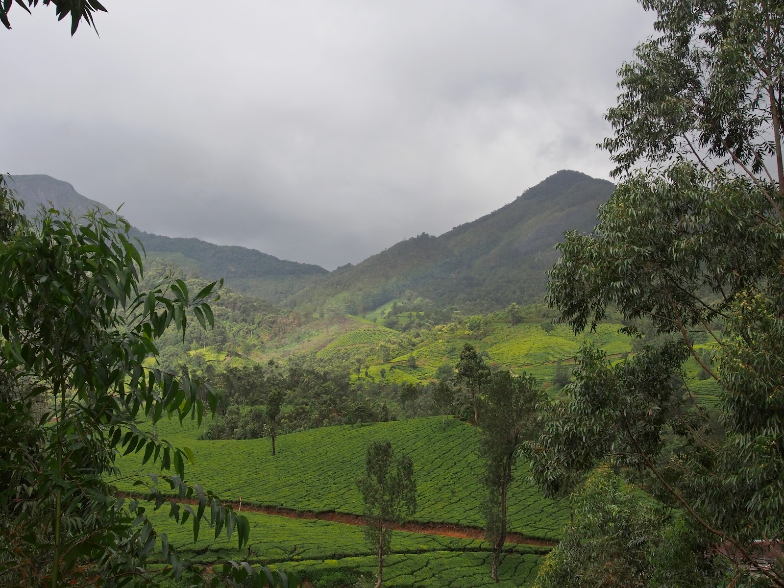
Kerala's claim to being "Gods own Country" is sounds really hollow and unconvincing most often than not. However, there is one part of this highly politicized state that really makes that statement meaningful; Munnar. Munnar is to Kerala like Ooty is to Tamilnadu. Higher altitudes of the Western Ghats with thousands of hectares of beautifully manicured tea plantations.


Since our Bandipur trip was scuttled by the powers that be, we had to think of an instant alternative for the Onam holidays. We had returned from Thekkady through Munnar in July and had not stopped to enjoy it's wild beauty. So we now had an opportunity that came knocking and we grabbed it with both hands.

Access to Munnar from where we live could be through two routes. One route takes you through Kerala on the NH-47 and at Ernakulam you turn into the NH-49 (Cochin-Madurai highway). The other route passes partly through Tamilnadu and re-enters Kerala at the border in Chinnar WLS. No prizes for guessing which route we prefer.

From Palakkad the road to Pollachi branches off to the right at Kootupatha. The road has recently been upgraded and is in excellent condition till Gopalapuram check post at the border.
Looking towards the Kerala side
Don't be fooled by the four-lane like portion just after the check post. It narrows down immediately after you cross the impressive statue of Thiruvalluvar!
Looking toward Tamilnadu side


The next 15 kilometers to Pollachi (Trip distance 48 kms) is full of potholes and it only improves 5 kilometers before the town. At the traffic signal at the bus stand take the right turn to Udumalapet. It is a good for the entire thirty kilometers.

When you reach Udumalapet (Trip distance 77 kms) the road to Munnar is on your right. You can't turn right there so you have to go to the end of the road and take a U-turn and then turn left to Munnar.
Approaching from Pollachi drive to the junction at the end of this road

Make an U-turn and come back to the traffic light for the Munnar road

The part through the town is confusing because a railway overbridge work is lying incomplete for many years now.
Take left here and any right after that

You'll have to take a left through a residential area and reach the Goverment Arts College where you have to turn right and catch the Munnar road, where you have to go left again. I drive by instinct and have never asked for direction but it will be better to stop and ask if you are driving for the first time, especially after dark!

After that it is fairly straight forward till you reach the first major junction where the Munnar road swings left. The road going straight reaches Thirumoorthy dam and the sign board is prominently placed so you can't lose your way.


At Amaravathi nagar (Trip distance 95 kms) you encounter the first in the series of 7 check posts. They rarely stop you at the Police check post but the Forest check post immediately next to it requires that you enter your details before proceeding forward.


This is the entrance to the Anaimalai Tiger Reserve. You are reminded to drive slowly through the forest and you might even rendezvous with a few pachyderms occasionally in one particular part of the stretch.


Single lane traffic throughout the Anaimalai Tiger Reserve. Be careful when you go off the road to allow oncoming traffic. The edge of the road in some places are quite steep and you can do your vehicle some damage. Trucks rarely make way for small vehicles so find a place with a smooth edge and wait for them to pass.


The road is worse in the "elephant" zone (above) and they have put an idiotic sign board along that stretch!! (left). How can you drive fast with so many potholes?!


The next check post is at the Tamilnadu-Kerala border where you are again made to enter your details in a register. Keep a few 10 rupee notes handy as the men at the Tamilnadu forest check posts aren't too shy about asking for a small 'something' especially if you have a non-TN registered vehicle!


Once you cross the bridge into Kerala you have three check posts, the Excise, Forest and Chinnar WLS entry (Trip distance 108 kms). You have to enter your details at the WLS check post again. Next to the check post is the eco-development committee office from where you can arrange treks into the WLS.


The last check post where you have to stop to make an entry is after the sandal forests, 15 km from Marayoor. A little after that is the Lakkom waterfalls, which is worth a small tea break!
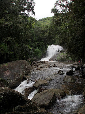
Lakkom falls in full flow
 

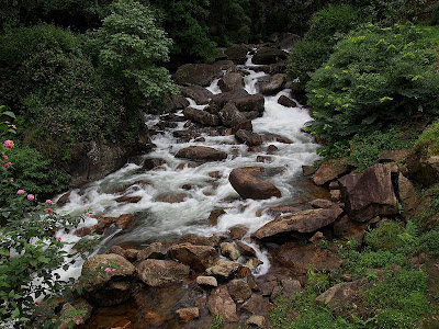
Downstream from the falls


The Eravikulam National Park (Trip distance 159 kms) is 35 kilometers from Marayoor and just 12 kilometers from Munnar. You will need to plan a half day trip if you want to have encounter with the Nilgiri Tahr, including the waiting time for the  shuttle buses that take you from the reception center to the park.


The entrance is now crowded with food stall and curio shops that make the traffic jams worse. We reached early enough to be on the first bus trips and avoid the holiday traffic.
The bridge in Munnar from the Chinnakanal road

Munnar town (Trip distance 172 kms) itself is very small, wrapped around the confluence of three streams. The road from Marayoor snakes through the main market and reaches a bridge on the left immediately after the IndianOil petrol station. The road running right goes to Adimaly through Pallivasal. You can go to the Idukki arch dam that way. If you take the left across the bridge the road divides at the end of it. The left will take you to Mattupetty, Kundala and Top Station. The right goes to Devikulam, Chinnakanal, Periyakanal and Poopara. From Poopara the left turn goes to Theni & Madurai and the straight road is to Kumily & Thekkady.

If you want to avoid the traffic there is an alternate route from Marayoor, passing through Kanthaloor, Anaimudi Shola, Kundala & Mattupetty. The 8 kilolmeters through tha Anaimudi shola will require a vehicle with good ground clearance. I will tell you about this route in subsequent blog.

I will place the links to the blogs related to each of the places I mention here as I update it....just follow the links as they come along