Showing posts with label Himalayas. Show all posts

Wednesday, October 11, 2023

Ladakh & Life Lessons - Part 10: Maitreya and Milky Way

 18th July 2023, Afternoon and Night

Khalsar - Diskit - Hunder - Terith


After the early lunch, our plan was to go to Diskit and Hunder, in the Nubra valley. We'd have to  backtrack towards Khalsar, cross the Shyok onto the road to Sumur and Siachen glacier, to reach Terith where our resort was. We were on our way to Diskit a little after 1.15 pm. The sun was beating down so mercilessly that it was hard to imagine that we were in a valley between the Himalayas and the Karakoram ranges. These are the two highest mountain ranges in the world but at that moment we felt like we were in Thar desert!


While this area with popular tourist spots is called the Nubra Valley, it is actually the Shyok valley. The river that runs south of Karakoram range is actually the Shyok, which eventually merges with the Indus in Pakistan near Skardu. The Nubra river itself flows south east through the valley and flows into the Shyok near Diskit. (Red arrow)


The road to Diskit and Hunder was being widened and repaired, as was the road from Khalsar to Pangong Tso. We made slow progress as we were occasionally forced to halt in the interest of safety, while the mountain sides were being ripped apart by earth moving equipment. The traffic build-up that was a consequence of this halt-and-go process ensured that looking at our watches was a futile exercise!


While doing my research for Ladakh, as I mentioned in my last post, I had been drawn towards a face. The face of Maitreya Buddha. He sits tall, below the Diskit Gompa, looking across the Shyok river and the mighty Karakoram mountains. I don't know what the magnetism it was, but though I hadn't been keen on exploring the monasteries in detail, Diskit was an exception. I had made a mental note to spend a few extra minutes here. 


We drove to the monastery first but the heat, with the very uncomfortable thermal wear inside, was unbearable. We were planning to check in at our resort only after going to the famous sand dunes of Hunder so getting out of the thermals was still a couple of hours away. We were hoping it would become colder as the sun disappeared behind the mountains on the west. So we abandoned the idea of a detailed exploration of the monastery and decided to go up to the Maitreya watching over the Shyok valley. 


The colossal statue of the Maitreya Buddha, 106 feet tall, can be seen from the monastery and is on a hillock across a small stream. Unfortunately, though the road goes to the base of the statue, vehicles were not permitted to go up when we went there. I wasn't about to allow the heat to stop me so I decided to walk it up. Maitreya had that effect on me. I had been reluctant to climb places that seemed to leave me breathless but it seemed that I was energised in his presence. 


A few minutes, sitting in contemplation before the serene Maitreya and I knew what I had to do with the rest of my life. I would have sat longer because I couldn't feel the heat any more but there were three people sitting in a baking car. So after a whispered prayer and a promise to be back, I walked back, spinning the many prayer drums as I descended. Something in me had clicked into place. I don't know what, but I felt that life was about to change sooner than later. 


We proceeded to the famous Hunder dunes hoping to see the double humped Bactrian camels. Sadly, the heat had got to them too. They weren't to be seen anywhere and the owner of a mobile food cart told us that they'd appear only after the sun went down. It was exhausting and the dunes weren't looking very inviting in the heat. Most of the wavy sand had been disturbed by the camels and tourists who had been there earlier. It didn't seem worthwhile to wait for a few hours till the camels appeared. 


For those staying in Diskit or Hunder, if you have the time, a two and a half hour (maybe more) drive will take you to Turtuk village, close to the line of control (LOC), on the border with Pakistan. Its fame is not only because it is the northernmost village on the Indian side of the LOC, but also because it is the largest producer of apricots in Ladakh.. Though many say it is a part of Pakistan, it was actually occupied by Pakistan after the 1948 Indo-Pak war, and later was wrested back from Pakistan by India in the 1971 war. Our itinerary didn't include Turtuk because of the limited number of days we had at our disposal. If you are intending to do everything possible around Diskit you might want to consider staying in Diskit / Hunder or even Turtuk for two nights. If you stay more than two days you can explore both sides of the Shyok, including Siachen. (More about Turtuk here)

All along the route there were talks of declining tourist footfall into Ladakh. The road access from Manali side was cut off due to floods, landslides and missing sections of the highway. Our trip itself was postponed by a fortnight and the weather in mid-July had us worried. There was talk about having to start the morning drive earlier than usual as the fast melting snow would flood the rivers by mid-day. In places where the rivers had to be crossed, the rising water could possibly block the already non-existent roads and tracks. 

The Milky Way was next on the priority list so we decided to go to the resort and check in. It had been a long warm day. and a little rest was welcome. At the Osay Khar resort we discovered that we were one of two families that had checked in. It was looking deserted. Terith, as I mentioned was on the opposite side of Diskit, across the Shyok. There was nothing else to do or see around the place. Siachen was too far for an evening drive. This property is on a private farm and has some 20 cottages, of which only two had occupants. It is totally cut off from civilization and meant for people who want some peace and quiet. The ATV rides, camel rides, go karting and zip line for the normal tourist is not on the road to Terith. So if you are that type of tourist better look for accommodation on the Khalsar - Hunder road, in or around Diskit.

Over a cup of tea and fresh pakoras, the manager told us about the resort and afterwards took us around. He, himself was from Himachal and was worried about his home and family there. During winter, when the resort closes for the season he returns to tend to his farm there. One of the reasons that Ladakh attracted me, besides Maitreya, were the birds. I could add so many new species to my life list, and Osay Khar was a good spot. Unfortunately we checked in in the evening and would be leaving by 6.30 am to avoid getting held up by a swollen Shyok. Birding in that area would have to wait for my next trip.


Dinner was served at 8, and having eaten, we went back to our cottage to set up for the Milky way. Fortunately, we wouldn't have to suffer light pollution. With only two cottages occupied the glare of artificial light interfering with our photography plans were reduced. Our postponed trip also turned out to be a blessing in disguise. The original dates for our trip fell during the week with a full moon day. A full moon would have spoilt our plans with its bright light. Our trip fell on a weekend when it was time for the new moon! We only had to worry about the clouds as the threat of rain still loomed. By the time the Milky Way made its spectacular display at half past 9, we were ready for it.


Of the top 10 locations in India to shoot the Milky Way in India, three are in Ladakh. Nubra Valley, where we were; Pangong Tso, to where we were going the next day and Hanle Dark Sky Reserve in the eastern side of Ladakh. We would miss the third location on this trip but that has been added to our bucket list! If you are keen on astrophotography yourself, plan your trip to coincide with the new moon day of that month.

The Milky Way was the icing on the cake for us. We had a long drive ahead of us the next day as the regular route to Pangong Tso was closed for widening. We'd be driving through the Shyok river bed for most of the route and didn't want to get caught in a flood. So we decided to pack up for the night and hit the bed. 

See you on the road to Pangong Tso!


Wednesday, September 13, 2023

Ladakh & Life Lessons - Part 6: Magnetic Myth & The Confluence

 July 17th 2023, 11.20 AM Srinagar - Leh Highway

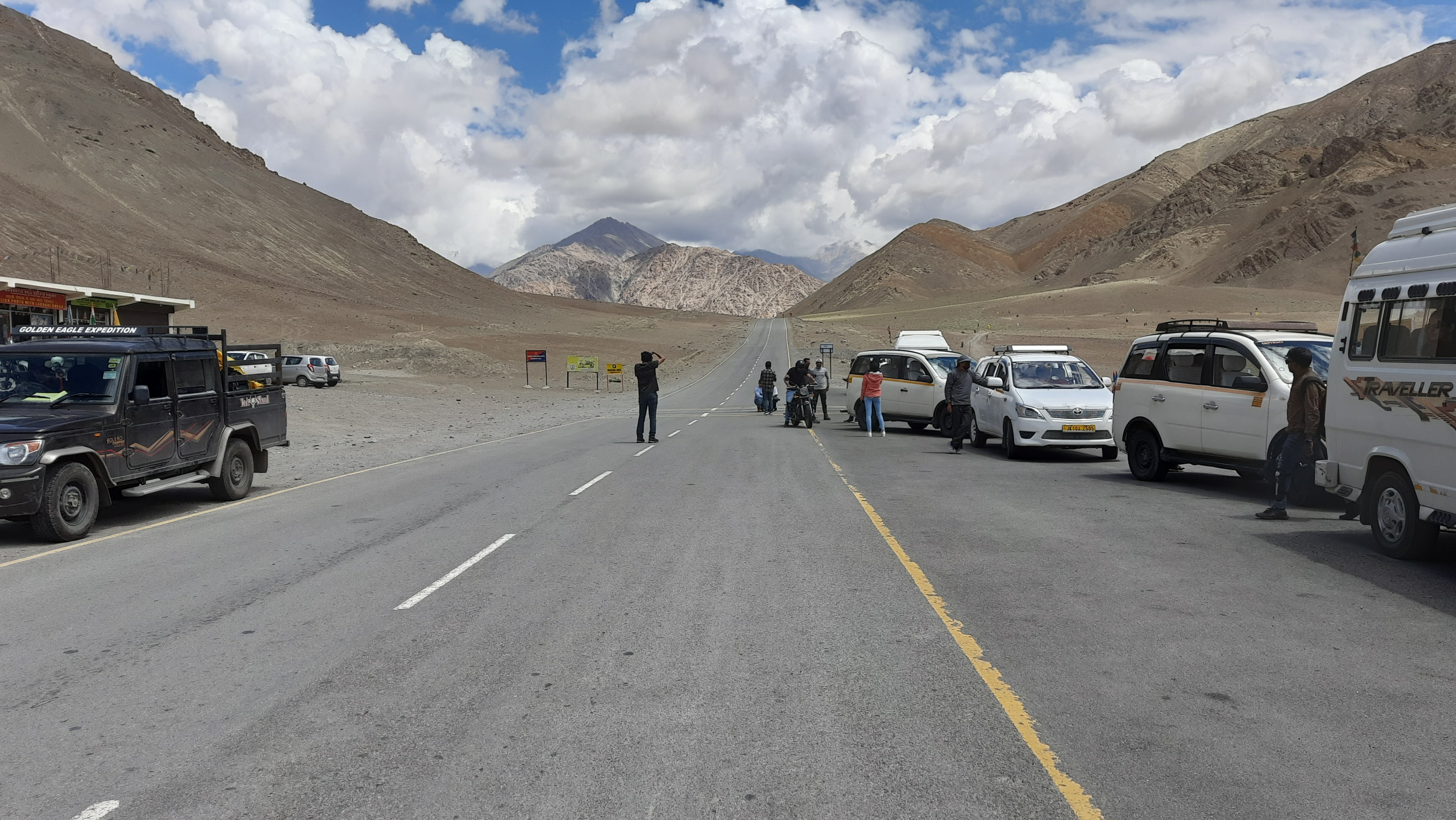
A little after quarter past eleven, we were at the famous Magnetic Hill. This location on the National Highway is famous, or should I say infamous, reputation for pulling vehicles up a slope and that too at 20 kmph!! It appears, every tourist to Leh, on their first visit will come here and 'gasp' at this phenomenon. Gasp, you will, not because of magnetism but because of the rarefied air. Let's take a few deep breaths and then investigate this astounding miracle!

Busting the Magnetic Hill Myth

According to the local myth vehicles parked in neutral with ignition switched off, will roll 'uphill' by themselves. There is painted box on the highway where you can park your vehicle and the feel it roll. It should roll from west to east, if it is going UP the slope. If you are that crazy type, you can even get off, pursue the runaway vehicle and hop on! Just that you should be able to run at 20 kmph, if the stories are to be believed. I wouldn't risk it because, suppose I did and ran after the vehicle at 20 kmph, at an altitude of around 11,500 feet (3500 metres), I would be on the ground rolling for breath in a few meters. I would be a victim of Acute Mountain Sickness and the vehicle would have rolled off the road at the end of the curve ahead. After all, I would have only had about 24 hours or slightly more to get acclimatised!

There are three explanations being bandied about to explain this extraordinary phenomenon. 

1. The first one is that the hill, that has this unique property, is believed to be a Gateway to Heaven and there existed a 'road' from top of the hill through which 'good' people went to heaven but 'bad' people wouldn't be able to. I'm only wondering; are all the cars filled with only 'good' people?! Maybe it is wormhole to another dimension. 

Personally, I think, with the current discord with my Gods, the Stairway to Heaven or more than likely the Road to Hell will be my option! (Please click the song names for some lovely music!) 

2. The second one attributes this phenomenon to a strong magnetic field emanating from the surrounding hills to the west that it pulls vehicles that are stationary. It is even said that planes avoid flying over this area due to magnetic interference. I am only wondering, how an airplane made predominantly of aluminum and composites, with less than 10% steel and flying between 35,000 to 40,000 above sea level will be affected by this. Starting to sound like Bermuda Triangle? Don't worry, no plane has crashed on the mountains here or disappeared through the 'wormhole' never to be seen again. I only have a simple question. Why didn't the coins in my pocket not fly out and get stuck on the hills? Are coins non-magnetic? Similarly, there will be so many small magnetic objects we carry on us. If a big 1 to 2 ton vehicle can be pulled, why not objects only weighing a few grams? A point to ponder.

3. The third explanation is that the obstruction of the horizon by the mountains creating an optical illusion that makes the road appear to be going upwards though it is actually going downwards. In any case, all three of us had good eyesight so we could see the road sloping from east to west. I feel, it is more of a case of 'been there, done that' for most travellers passing Magnetic Hill. A good yarn to spin after getting back home. 

We too joined the enthusiastic folk testing out the magnetism of the hill but I was only increasingly convinced that it is a hoax that has been fuelled up to have been made into a myth. Our car travelling from Leh was going downward on the slope. The point where the box for parking the vehicle seemed slightly level and further down the road slopes downwards again. Tsewangji parked our car in the designated spot and the car simply rolled downhill, not uphill!


While we were standing there a truck came labouring its way across the slope. It the hills were truly magnetic on top of the slope (east) it should have gone up the slope effortlessly, aided by magnetism! It is hard to believe that sensible people fall for this trick. 


The road, without doubt is visibly sloping downwards from east to west and it would require really bad eyesight to induce yourself to see it any other way. There certainly is no optical illusion either. If you feel there is, do come to us. Both, my wife and I happen to be ophthalmologists!

The Confluence

After the disappointment of Magnetic Hill, we drove further down the highway to the Indus - Zanskar Sangam (Confluence). Not too far away from Magnetic Hill, it is a 10 or 15 minute drive depending on stops in between. As you cross the army area, the road swings right and below the road, on the left, you will get your first look at the Indus river flowing at the bottom of the valley.

Standing on the road, the Indus doesn't look very impressive with it's placid looking flow. The recent rains and fast melting snow, had made the Indus the colour of coffee. Our visions of clear blue water were definitely muddied. Further up after the next curve you will realise why the Indus flows placidly. 


It meets the Zanskar river headlong and almost a right angles. You can differentiate the waters of both rivers by their individual hues. The Indus is mostly the dirtier of the two, and Sangam more cleaner and blue, but this time both rivers had muddy water due to the heavy rainfall and Indus more so. 


The Sangam is a very impressive sight when viewed from top, standing on the edge of the  Leh - Srinagar highway.  Before the rains strike the rivers are a fraction of their width (see picture below) with the sandbanks exposed. (Pic Courtesy: Vargis Khan) 

The Indus river system is one of the world's largest. The source of the river is in Tibet, from where it flows north-west into through the Chinese occupied part of Ladakh, into India. The Zanskar joins it first, and then the Shyok beyond Nubra valley, in Pakistan occupied Kashmir. This north-west flowing river takes a south-west turn in Pakistan and many tributaries join it along the way. The five rivers of Punjab, the Jhelum, Chenab, Ravi, Beas and Sutlej join it before it flows south into the Arabian sea. (Pic Courtesy: burningcompass.com)


At Sangam the new road, along the edge of Zanskar, to Chilling is almost complete. It is from Chilling that the Chadar Trek (Link in name) starts. It is a deep winter trek of around 60 kilometres to be covered over a week or more. Temperatures can plunge to -20 degrees at night and it is not a trek for the faint hearted.  


There are two things you can do at the Sangam. Go to the cafeteria and refresh yourself and later, if mood, time and the crowd permits, go rafting on the river. Of course, don't forget the mandatory photographs before leaving back to Leh because it will be past noon by the time you finish the visit to the Confluence. You can explore the road to Chilling or beyond Nimmoo but it was getting too hot and it had been a tiring morning. The cafeteria didn't have anything to tempt us to go for an early lunch either so we would have to make a lunch stop on the way back. (More about food in Ladakh in a later post.)

We had one more stop before heading to Leh. That will be for a subsequent post. 


Thursday, August 17, 2023

Ladakh & Life Lessons - Part 2: Satellite phones and security woes

July 16th 2023, 2.00 AM  - New Delhi Airport

Finally, after the delay, our journey was rolling. We landed in the Terminal 2 of the IGI Airport, Delhi, got our luggage and decided to leg it to Terminal 3 from where we were to catch the next flight to Leh. We had a little over four hours and it seemed like a good idea to check in our luggage and proceed to the waiting lounge. The Delhi airport was impressively huge and boarding for our flight was from the distant, Gate 50. 

Checking in our luggage was quick. Despite the odd hour, the Vistara staff were quite alert. Having finished that part, we proceeded to security check. The belt and shoes had to come off. All electronic gadgets were placed in a separate tray for screening. To this day, I don't know why, but I was under the impression that x-rays could penetrate a humble camera bag, or any bag for that matter. Anyway, I had more trays than a normal passenger. Sliding my trays onto the conveyor, I proceeded for my metal detector sweep. That was a mere formality and I went to the other end of the converyor, awaiting my trays. 

My son and wife had got their stuff passed through without a problem but I was still waiting. I could see that my tray was out but the chap in charge of the screening was having a small discussion with a burly officer about my camera bag. There were a few other passengers too explaining the contents of their hand baggage. When my turn came, the expression on the security officer's face became very stern. The conversation went some thing like this. Since it was carried out in Hindi,  I've translated it here so that the reader is aware of the seriousness of my 'crime'! 

"Why are you carrying satellite phones? Don't you know it is not allowed?" I was taken aback. I had a rather simple smartphone and was wondering how this gentleman decided it was a satellite phone. 

"I don't have a satellite phone, Sir", I said.

"Open your bag", was the curt reply, and his expression was becoming more frightening. I was now worried that someone had stuffed something into my bag without my knowledge and I was probably going to get arrested for no fault of mine. It happens all the time and I had probably, inadvertently, become a 'courier' for some underworld organisation. Who else smuggled satellite phones?!

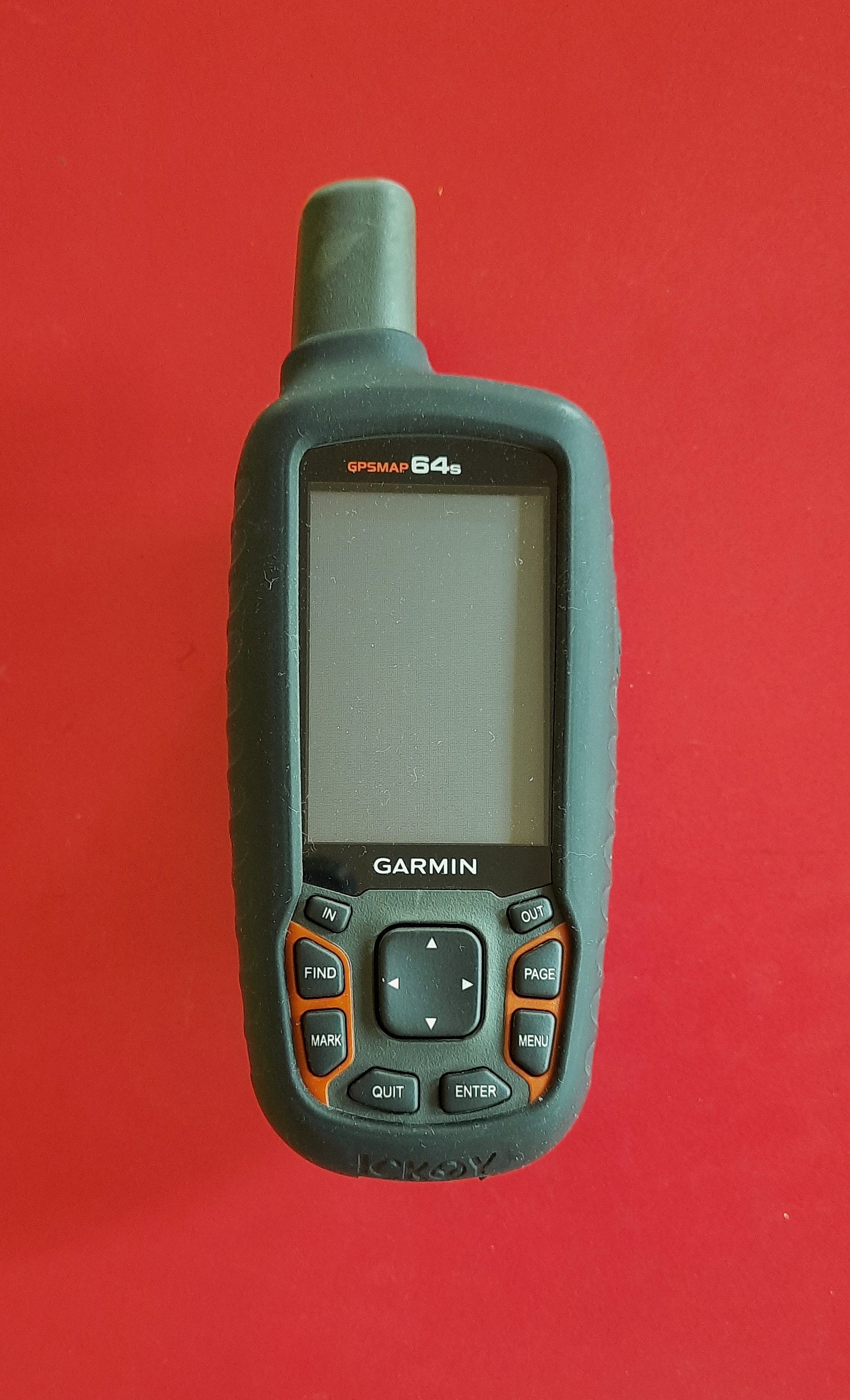
I opened the front compartment of my bag. "There; take those two phones out", he barked. I felt my head reeling. The 'satellite phones' that I was accused of carrying were two electronic gadgets, I forgot to put in the tray separately. My Garmin Marine GPS and my Zoom Audio Recorder!


"Where are you going? Why do you carry satellite phones?". He was still very irritated with me for holding up the line. A satellite phone on a passenger, apparently, is not allowed without proper authorisation. 

"Sir, they are not satellite phones. One is a handheld GPS and the other one is a sound recorder", I told him as politely as I could, without gnashing my teeth, and explained the reason I was carrying it. His assistant also confirmed that they were not satellite phones! 

Now, I was happy that the matter seemed to have been settled but for a six foot tall security officer, he probably had an ego taller than him and it wouldn't permit him to admit his error. It apparently took a lot to climb down from his high perch. He picked up the GPS and told me, "You cannot carry this", with a finality in his voice.

I was stumped. Was he going to confiscate it? I was in no mood to argue with him at 3.00 AM in the morning. Once again, I very politely told him that there had to be a middle path. There was no rule against carrying a GPS handset. Fortunately for me, his superior officer walked into the scene and I was told to meet him and see if the problem could be resolved. This nice gentleman took one look at the masquerading 'satellite phone' and confirmed that it was indeed a GPS handset but since he couldn't embarrass his subordinate, he gave a quick solution. He told me to take out the batteries and put it the check in luggage! 

This was getting more complicated. We had already checked in our luggage half an hour ago and it probably would have been in one of the luggage trailers on its way to our aircraft. I told him that it would be difficult to retrieve our baggage now as they would be half way across his rather extensive airfield. I couldn't request the airline to bring the bags out for me to put it in. In any case, I was out of security check, in the boarding area. The boss then suggested that we use one of our hand luggage to keep the offending GPS and check that in. 

Luckily, my wife's backpack came to my rescue. I put the GPS in it and rushed out not wanting to prolong this unpleasant drama. As I reached the entry point to the security check area, I realised that in my hurry, I hadn't retrieved my cell phone or carried my boarding pass. Both were critical. The former for any 'emergency' calls in case I was stopped and arrested and the latter to ensure that I could get back to the boarding zone as a 'genuine' passenger! 

So. back I went, through the metal detector zone, picked up the critical objects and waded through the crowd, back to the baggage check in counters. The eye brows of the girl who was at the counter almost touched her hairline when I told her why I was back. "You can carry this bag with you, Sir", she said. I patiently explained to her, my rather  'complicated' situation, and told her that I wasn't about to abandon my GPS at the airport. After checking in the bag, (luckily there wasn't an excess baggage situation), I retraced my way back to security check. 

I thought I could walk in a 'free' man as I had been screened twice over. The guy with the metal detector was very sympathetic but he said, rules are rules. I had to take out my shoes and belt, and put it through the screening tray procedure all over again! In the middle of all that he had time to enquire regarding my profession and ask my why I was carrying all these strange gadgets. As he waved me through, he stopped me again and asked me regarding 'laser to remove his glasses'! What a night!

Finally, after all the confusion, security check was over and it was time to catch the next flight to Leh. All this excitement had effectively driven away any thoughts of sleep. It was a long tiring night and I was sweating despite the air-conditioning. Though I had skipped the Muscular Upma on the Indigo flight, I was optimistic that our Vistara would serve something more appetising. So we took a break at the McDonald's near the lounges, which were anyway full; before proceeding to look for Gate 50. My son, despite the noodles served on the flight, happily tucked into a burger and fries, while I sipped a cold coffee to settle my jangling nerves.

After refreshing ourselves we proceeded to 'Area 50' of Terminal 3. Mercifully, there weren't any alien types to scan me for more banned objects! Most of the chairs were empty so we plopped ourselves next to a mobile charging station and decided to catch a few winks before boarding the flight to Leh.


By 6.00 AM it was getting brighter outside despite the heavy cloud cover. We had been worried. Already a delayed flight and 'satellite phones' had ruined our night. So this was a welcome relief as it wasn't raining.

By 7.15 we were airborne, and over the clouds the sun was shining. At last, we were on our way without any further delays.

It was a  short hop. In a little more than an hour the pilot announced that he was preparing for landing. As a sign of nearing our destination, the snow capped tips of the Himalayas greeted us through the clouds.

The sky was broodingly depressing. Over the previous few days the television channels had been full of news of cloudbursts, flash floods and roads being washed away. The Manali - Leh National highway 3 was closed and we were worried about our trip as travel in Ladakh is completely dependent of the state of the roads.

As the flaps were raised for landing we knew that Leh was only a few minutes away beneath us. It had been a very eventful night. We had travelled 3500 kilometres in about 12 hours, and climbed from 140 meters above MSL in the Palghat Gap to above 3500 meters above MSL in Ladakh. An unforgettable experience!


The weather wasn't very encouraging as the aircraft dipped through some clouds before landing. However, what mattered wasn't the weather, but that we had reached our destination without any major hiccups.

Oh! By the way, Vistara too served upma for breakfast, albeit it wasn't a 'muscular' one! If anyone offers me upma anytime soon, I'll crack their skull open!

Please wait for further updates. We have two days to acclimatize to the low oxygen atmosphere.......